
Mount Agung Erupts, Its Booming Sound Heard from Rendang Post
Artaya - atnews
Karangasem, 13/5 (Atnews)—
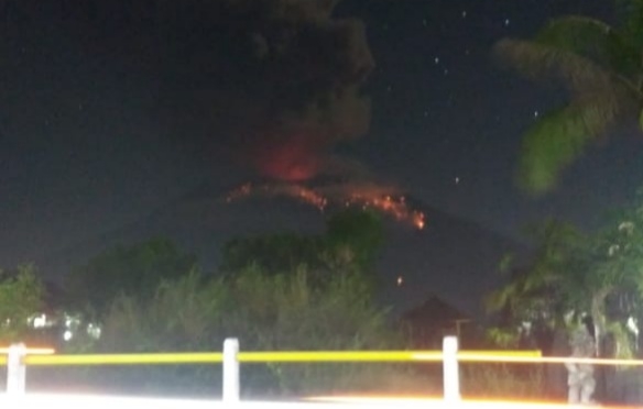
The boom at the Rendang Post was heard from the eruption of Mount Agung, Bali, on Sunday night (May 12) at 22:29, but the ash column height was not observed.
The event is recorded on a seismogram with maximum amplitude of 25 mm with duration of ± 2 minutes 16 seconds.
Ministry of Energy and Mineral Resources, Geology Agency, Center for Volcanology and Geological Hazard Mitigation (PVMBG) and Volcanic Observation Post reported that currently Mount Agung is in the Level III Status (Advisory).
Communities around Mount Agung and climbers / visitors / tourists are asked not to be, not to climb and not carry out any activities in the Hazard Estimated Zone, namely in all the areas within the radius of 4 km from crater top of the Mount Agung.
The Estimated Hazard Zone is dynamic and continues to be evaluated and can be changed at any time to follow the latest / most up-to-date observation data of the Mount Agung.
Communities living and moving around the rivers having the upstream in the Mount Agung are expected to be aware of potential secondary hazards in the form of rain lava flows that can occur especially in the rainy season and if the eruption material is still exposed in the peak area. The land area flowed by rain lava follows the river having the upstream in Mount Agung. (*/ika)

Baca Artikel Menarik Lainnya : Aktif Bayar Pajak Dukung Pembangunan Nasional


